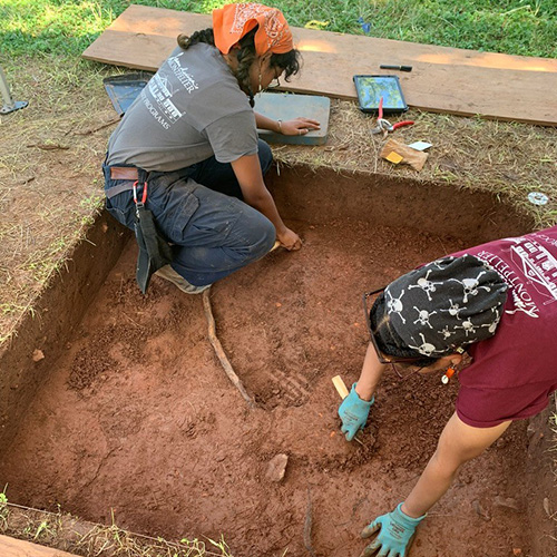
It was the end of a long day of digging in the Kuril Islands. A team of archaeologists was about to pack up for the evening when UW student Matt Walsh spotted a piece of whale bone in the excavated pit. Carefully removing it, he discovered that the bone had been worked with a carving tool.

The discovery wasn’t of the heart-thumping Indiana Jones variety, but it will provide clues about past human activity on the island. Such clues, along with geological findings, are enabling researchers to piece together a history of the islands.
That’s the goal of the Kuril Biocomplexity Project (KBP), a five-year, $2.4 million National Science Foundation project led by Ben Fitzhugh, UW associate professor of anthropology. The research team is looking at the geological, biological, and archaeological record in the Kuril Islands to learn how natural events may have affected the islands’ climate and, in turn, influenced animal and human activity.
The Kuril Islands, an archipelago of about 40 islands in the Pacific, stretch from a temperate climate near Japan to subarctic and arctic climates of Kamchatka, east of Siberia. This variation in climate, coupled with the islands’ relative isolation, makes the Kurils a particularly intriguing research subject. The islands are largely uninhabited today, but previous excavations indicate that various groups have lived on the islands over the past 5,000 years.

“In a sense, we can use these isolated islands as laboratories,” says Fitzhugh. “We can see what animals do in one climate and not another. We can see how climate change has affected these regions for thousands of years, and we can look at how people and animals have responded. If we can understand what has happened in this simple system, then we can begin to apply what we learn to more complex systems.”
Fitzhugh is joined by colleagues from the UW Departments of Anthropology, Earth and Space Sciences, Atmospheric Sciences, and the Quaternary Research Center, plus more than a dozen Japanese and Russian scientists. A middle school teacher from Bellingham, Washington is also on the team; she is sharing the experience with thousands of teens via the Internet.
While the archaeologists are digging to uncover human activity on the islands, geologists are searching the soil for a record of geologic events. Volcanic eruptions leave behind ash; tsunamis, caused by earthquakes, deposit sand. The ash and sand, found as layers in the soil, can be dated to understand when events occurred.
Still more clues can be found in pollen, which accumulates in the sediment of the islands’ lakes and ponds. Durable and datable, pollen provides information about the islands’ vegetation history. And animal bones found on site can be analyzed to identify species, sex, age, and stress level. Adding together all these bits of information, a picture of the islands’ history begins to emerge.

The KBP team has spent two summers on site, traveling from island to island by boat. In 2006, team members visited as many islands as possible to identify promising sites. In 2007, they spent more time at fewer sites, excavating and collecting samples. After one more field season, they will spend two years analyzing their samples in the laboratory and creating computer models of the past climate and its impact on plant and animal life.
“That first year was very quick and dirty,” says Matt Walsh, an undergraduate majoring in archaeology, who has participated both years. “This year there was a lot more site-specific intensity. We spent more than two weeks at a site we’d visited for just one day last year.”
But even short forays have yielded results. Finding house pits—sites where people once lived—is not difficult if one knows how and where to look. The most obvious clue? Pit depressions. Fitzhugh explains that the Jomon people, whose presence in the Kuril Islands dates back at least 5,000 years, built earth houses on high terraces, with half of the structure underground. “When the roofs of these houses collapse, it is pretty obvious from the surface,” says Fitzhugh. “Sometimes you can walk right into them.”
Or fall into them. Wading through heavy brush in some areas, team members realize they’ve found a house pit when they tumble into it. “To the person walking behind you, it looks like you’ve suddenly disappeared,” says Walsh with a laugh. “It’s very cartoonish.”

Where house pits are located, middens—garbage piles containing shells and bones of long-forgotten meals, pottery shards, and other detritus of daily living—are often nearby, providing further clues to the past.
While the KBP team’s archaeologists explore house pits and middens, the geologists do their own excavations, looking for layers of volcanic ash and tsunami sand. The first year they dug quickly and measured topographic profiles on many islands; this year they measured dense arrays of more than 60 profiles in the middle Kurils.
“In our work, any one excavation is not very exciting,” says Jody Bourgeois, professor of earth and space sciences. “What gets interesting is when you get two or more excavations and you find a pattern.”
One thing the team has been studying is the prehistory of tsunamis in the Kuril Islands. “The sand layers provide clues,” says Bourgeois. “When you find a buried sand layer at eight meters above sea level, you know it’s from a tsunami.”
Another clue: your camp from the previous year is completely destroyed. That’s what happened on the island of Matua. A small group from the KBP team explored the island in 2006, camping near the beach. Returning in 2007, they found the beach obliterated and World War II military structures—long buried by ash from a 1946 eruption — uncovered by the tsunami. They completed topographic profiles that indicated the tsunami had reached up to 20 meters, or 65 feet—which explains why past Kuril Island inhabitants made their homes on raised terraces rather than the beach.

Bourgeois cringes when asked whether one more field season will yield all the information she needs. “Next summer can’t be the last field summer,” she groans. “There’s always more to do.”
Fitzhugh agrees, but he is pleased with what the team has already accomplished. And he’s looking forward to the analysis and computer modeling that is still to come.
“I think we’ll have a good sample,” says Fitzhugh. “With archaeology like this over such a broad area, there’s a trade-off between the amount of area you cover and the detail of the work. I think we’ll come out with a good story in the end, with enough information to refine our models and test our ideas. It will be a strong foundation for more work there and in other places.”
More Stories
Unearthing Clues to Past Lives
Through summer excavations at a former plantation and an anthropology honors thesis, Raquel Matthews is advancing our understanding of the lives of enslaved people who lived there.
A Second Life for Plastics
Chemistry professor Matthew Golder and his research team are exploring ways to alter the chemical structure of plastics to keep them out of landfills.

Nicole McNichols Wants to Improve Your Love Life
In her new book, "You Could Be Having Better Sex," psychology professor Nicole McNichols shares frank information based on academic research.